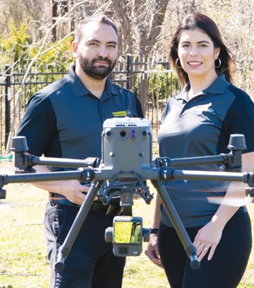
Precision technology and aerial imagery have been shaping agronomic decisions for researchers and agri-businesses for years. TerraNova UAV, a prominent agricultural drone service company based in Ontario, plays a pivotal role in driving this transition in Canada.
It combines the best of drone technology, high resolution multi-spectral imagery, photogrammetry, and artificial intelligence (AI) to provide farmers with information on their fields. The detailed maps and close-up pictures along with analyses help reduce farming costs, greenhouse gas emissions and improve crop yields.
“Farmers are our end users. We ensure that they get the most value out of our imaging technology,” says Andres Hurtado, co-founder of TerraNova UAV.
Primarily catering to farmers, the company gradually gained traction from researchers, government agencies and agri-businesses seeking sustainable crop management and farming practices.
The TerraNova UAV team conducts aerial surveys of the farms, gathering multi-spectral imagery required by researchers or agri-businesses and shares it with both clients and participating farmers. While the projects may be financed by the government or businesses, farmers receive tangible advantages from the resulting insights and information gained from the collaboration. This B2B model ensures that TerraNova UAV’s technology is available in wider markets.
Their agricultural drones are equipped with special cameras that capture various light bands, including red edge and near infrared that are beyond the visible spectrum. The acquired data from images is processed using state-of-the-art mapping software, AI, cloud computing and agricultural expertise to develop multiple plant algorithms. These algorithms generate live maps providing insights into plant health, soil moisture, pest and weed detection and more. The maps are then shared with clients through a platform, which allows measuring and annotating findings.
The company’s latest development is the integration of light detection and ranging (LIDAR) capabilities—a remote sensing method that uses laser light to measure distances—into its drone operations. Deploying a laser-equipped drone, highly detailed 3D models of fields and forests can be generated. This enables TerraNova UAV to cater to conservation authorities and forestry and archaeology departments.
In areas where a closer examination is needed, the team uses geo-referencing technology to identify points on the map and dispatches a high-resolution camera drone to capture detailed images. These images provide valuable insights, enabling the detection of plant diseases, signs of seed quality and indications of pest damage or drought.
In a notable instance, the team directly assisted a farmer impacted by heavy frost that led to a significant loss of his tomato plant population. Conventional high-resolution imagery was ineffective in making replanting decisions due to a thick layer of dust that covered the crop. The TerraNova UAV team deployed a multi-spectral drone and developed a custom vegetation algorithm to detect chlorophyll signatures even through the dust. The resulting detailed map allowed the farmer to identify areas with high and low plant populations accurately. Using the interactive map accessible on his handheld device, the farmer could easily navigate the field and decide where replanting was necessary.
TerraNova UAV is currently focused on integrating new technologies into its services. This includes combining multi-spectral and laser technologies while implementing thermal imagery. Plans for expanding the team are also underway, as the company seeks researchers and agronomists to continue exploring innovative methods for extracting valuable information from plants. Recruiting new pilots to support its growing operations is also on their agenda.
On a mission to help farmers to optimize crop yields through its state-of-the-art agricultural drone technology, TerraNova UAV emerges as a trusted ally for growers, researchers and agri-businesses seeking to take sustainability, precision and productivity in farming to new heights.
It combines the best of drone technology, high resolution multi-spectral imagery, photogrammetry, and artificial intelligence (AI) to provide farmers with information on their fields. The detailed maps and close-up pictures along with analyses help reduce farming costs, greenhouse gas emissions and improve crop yields.
“Farmers are our end users. We ensure that they get the most value out of our imaging technology,” says Andres Hurtado, co-founder of TerraNova UAV.
Primarily catering to farmers, the company gradually gained traction from researchers, government agencies and agri-businesses seeking sustainable crop management and farming practices.
The TerraNova UAV team conducts aerial surveys of the farms, gathering multi-spectral imagery required by researchers or agri-businesses and shares it with both clients and participating farmers. While the projects may be financed by the government or businesses, farmers receive tangible advantages from the resulting insights and information gained from the collaboration. This B2B model ensures that TerraNova UAV’s technology is available in wider markets.
Their agricultural drones are equipped with special cameras that capture various light bands, including red edge and near infrared that are beyond the visible spectrum. The acquired data from images is processed using state-of-the-art mapping software, AI, cloud computing and agricultural expertise to develop multiple plant algorithms. These algorithms generate live maps providing insights into plant health, soil moisture, pest and weed detection and more. The maps are then shared with clients through a platform, which allows measuring and annotating findings.
Farmers are our end users. We ensure that they get the most value out of our agricultural drone technology
In areas where a closer examination is needed, the team uses geo-referencing technology to identify points on the map and dispatches a high-resolution camera drone to capture detailed images. These images provide valuable insights, enabling the detection of plant diseases, signs of seed quality and indications of pest damage or drought.
In a notable instance, the team directly assisted a farmer impacted by heavy frost that led to a significant loss of his tomato plant population. Conventional high-resolution imagery was ineffective in making replanting decisions due to a thick layer of dust that covered the crop. The TerraNova UAV team deployed a multi-spectral drone and developed a custom vegetation algorithm to detect chlorophyll signatures even through the dust. The resulting detailed map allowed the farmer to identify areas with high and low plant populations accurately. Using the interactive map accessible on his handheld device, the farmer could easily navigate the field and decide where replanting was necessary.
TerraNova UAV is currently focused on integrating new technologies into its services. This includes combining multi-spectral and laser technologies while implementing thermal imagery. Plans for expanding the team are also underway, as the company seeks researchers and agronomists to continue exploring innovative methods for extracting valuable information from plants. Recruiting new pilots to support its growing operations is also on their agenda.
On a mission to help farmers to optimize crop yields through its state-of-the-art agricultural drone technology, TerraNova UAV emerges as a trusted ally for growers, researchers and agri-businesses seeking to take sustainability, precision and productivity in farming to new heights.
Thank you for Subscribing to Agri Business Review Weekly Brief


